2012-09-29 By Robbin Laird
As the United States and its allies deal with the various challenges in the Pacific, including enhanced PRC capabilities and assertiveness, geography has a significant impact.
As Robert Kaplan has recently underscored, geography remains significant as an explainer for the world’s conflicts as well as bounding our understanding of the challenges ahead.
Unfortunately in the whimsical world of globalization, the assumption seems to be the world is flat and that somehow defines challenges on the same dimension. We often hear about the challenges to the “global commons” as if globalization has coughed up a multiple sum governing process.
It clearly has not.
To quote Kaplan:
Technology has collapsed distance, but it has hardly negated geography. Rather, it has increased the preciousness of disputed territory. As the Yale scholar Paul Bracken observes, the “finite size of the earth” is now itself a force for instability: The Eurasian land mass has become a string of overlapping missile ranges, with crowds in megacities inflamed by mass media about patches of ground in Palestine and Kashmir. Counterintuitive though it may seem, the way to grasp what is happening in this world of instantaneous news is to rediscover something basic: the spatial representation of humanity’s divisions, possibilities and—most important—constraints. The map leads us to the right sorts of questions.
Why, for example, are headlines screaming about the islands of the South China Sea? As the Pacific antechamber to the Indian Ocean, this sea connects the energy-rich Middle East and the emerging middle-class fleshpots of East Asia. It is also thought to contain significant stores of hydrocarbons. China thinks of the South China Sea much as the U.S. thinks of the Caribbean: as a blue-water extension of its mainland. Vietnam and the Philippines also abut this crucial body of water, which is why we are seeing maritime brinkmanship on all sides. It is a battle not of ideas but of physical space. The same can be said of the continuing dispute between Japan and Russia over the South Kuril Islands.
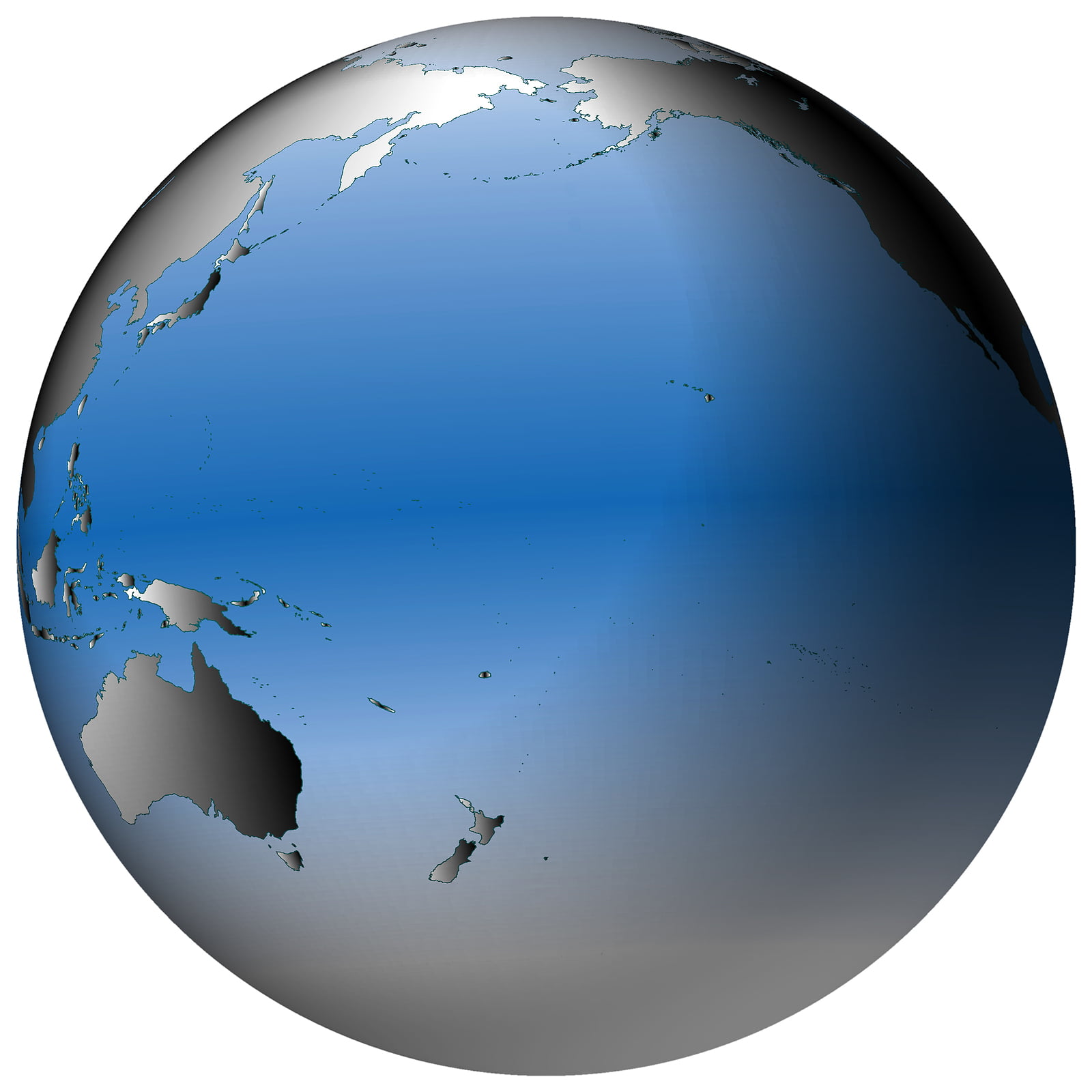
The Pacific is certainly a key definer of 21st century strategic reality for the United States, and that reality is the tyranny of distance. And the tyranny of distance challenges the persistent presence which an effective 21st century defense and security strategy for the United States needs to be built upon.

As Ed Timperlake has underscored in our series on the SLD Forum on China and the Pacific:
The key to understanding any human conflicts in the Pacific is to first recognize both the natural power and size of that Ocean…..
The Pacific is nothing like the name –“Pacificum” or peaceful in Latin. It is a violent and expansive Ocean. Rounding the tip of South America. Ferdinand Magellan, in perhaps one of the more significant “name branding” mistakes in history pronounced the body of water he saw as peaceful….
The answer to the question how large is the Pacific is very simple — it is huge.
“The Size of the Pacific Ocean is Massive; it covers more than one-third of the earth’s surface, which is approximately 165 million square kilometers (about 65 million square miles). It extends about 15,000 kilometers (9,600 miles).”
The question of how dangerous and violent is the Pacific was answered by Sir Francis Beaufort in the 19th Century in his code measuring storms at sea “The Beaufort Scale.”
After being wounded several times and commanding a Royal Navy ship of war Beaufort became Hydrographer of the Royal Navy for twenty-five years. In fact some of his charts are still used to this day. Sir Francis was a visionary who specifically recognized the strategic importance of the entire Pacific and he also focused on the strategic importance of the Arctic.
His “Beaufort Scale” runs from 1 to 12 with a Force 12 being “Hurricane Winds.” –“Huge waves and sea is completely white with foam and driving spray greatly reduces visibility”.
However, in 2006 the Peoples Republic of China adopted a scale that goes to a high of 17 to acknowledge what they saw as the power of a tropical cyclone off their shore known as a “Chinese Typhoon.”
Consequently, all ocean going mariners, from early explores on war canoes, to Chinese Junks, to European sailing vessels to modern battle fleets must have a very healthy respect for the pure raw power and also extremely significant distances involved with the Pacific Ocean.
It is still very true that even a 21st Century Navy can only venture forth with ships and planes that are rugged, survivable and have the range to go up against both nature and in combat against a reactive enemy — it is not as easy as the US Navy makes it look.
A famous World War Pacific Typhoon makes that startling point. Historians have debated the number of USN Ships sunk by Japanese Kamikaze attacks during all of WW II in the Pacific. Their counts vary from a low of 34 to a high of 47.
Compare that Kamikaze fight against a reactive enemy over a almost a four year war with a US Task Force caught in a Pacific Typhoon in one 24 hour period.
In the Pacific Typhoon of December 18, 1944 three Destroyers capsized; the USS Spence, USS Hull, USS Monaghan, with the loss of most of their crew–over 700 hundred sailors perished. Additionally, 146 aircraft on Fleet Carriers were struck from the rolls because of damage. So yes being capable mariners along with rugged ships and planes makes a huge difference.
The tyranny of distance and the challenge of providing persistent presence will be beyond the kin of the United States with declining assets in the 21st century, if 20th century concepts of operations persist.
What is needed is another look at geography and another way of thinking about military approaches with allies and collaborative technologies.
One way to think about this is to look at the forward side of the Pacific. The closer in side of the Pacific from Hawaii back involves the defense of the littorals and the key roles of Alaska and the Artic.
Looking west of Hawaii, the United States operates in two strategic geometries.

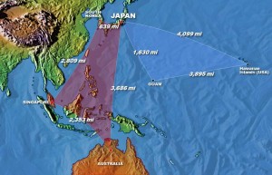
The first strategic geometry involves the triangle from Hawaii to Guam to Japan. This triangle is at the heart of the ability of the U.S. to project power into the Western Pacific. With a 20th century approach which is platform centric and rooted in step by step augmentation of force, each key part of the triangle needs to be populated with significant numbers of platforms which can be pushed forward.
To be clear, having capability in this triangle is a key element of what the United States can bring to the party for Pacific operations, and remains fundamental.
But with a new approach to an attack and defense enterprise, one would use this capability differently from simply providing for PUSH forward and sequential escalation dominance.
Rather than focusing simply on the image of projecting power forward, the enablement of a strategic quadrangle in the Western Pacific is crucial to any successful allied or American Pacific defense and security strategy.
Competition among allies in the Western Pacific is historically rooted and as a former 7th USAF commander underscored, “history still matters in impeding allied cooperation.”
In spite of these challenges and impediments, shaping a strong collaborative quadrangle from Japan, to South Korea, to Singapore to Australia can shape new possibilities.
Enabling the quadrangle to do a better job of defending itself and shaping interoperability across separate nations has to become a central strategic American goal. This will require significant cultural change for the United States.
Shaping capabilities to operate in both in the 21st century will see the need to craft an effective synergy between US and allied assets, or we will suffer a Ben Franklin moment: “We will all hang separately or we will hang together.”
In a later piece, I will look at ways to enable a new approach to an attack and defense enterprise in the Pacific crafted to encompass both strategic geometries: the strategic triangle and the quadrangle.
Rather than thinking of allies after we think about our own strategy, we need to reverse the logic.
Without enabled allies in the Western Pacific, the United States will simply NOT be able to execute an effective Pacific strategy. Full stop.
We are not about to have a 600-ship navy, and putting LCS’s into Singapore is a metaphor for the problem, not the solution.
The quadrangle of Japan, South Korea, Australia and Singapore can be populated by systems, which enable the shaping of a C5ISR grid that can able a honeycomb of deployed forces.
The population of the area with various sensors aboard new tankers, fighter aircraft, air battle managers, UAVs or aboard ships and submarines creates the pre-condition for shaping a powerful grid of intersecting capabilities.
Indeed, an attack and defense enterprise in the Western Pacific can be shaped which the United States can easily plug into, if indeed interoperability and mutually leveraging one another’s capabilities is seen as the strategic goal of the new Pacific strategy.
This will require culture change, and not only by the Asian powers.


